(NEXSTAR) – After months of anticipation, La Niña has officially begun.
The Climate Prediction Center announced Thursday that La Niña is expected to develop in September and last through at least the end of the year.
La Niña events typically reach their peak in the winter. This means that this time of year has the biggest impact on the weather we see, especially the amount of precipitation. But this year, forecasters expect a much weaker La Niña event.
Florida is one of the most dangerous cities for drivers, study says
Here’s what this means for winter weather across the United States in 2025 and early 2026.
What happens during a typical La Niña winter?
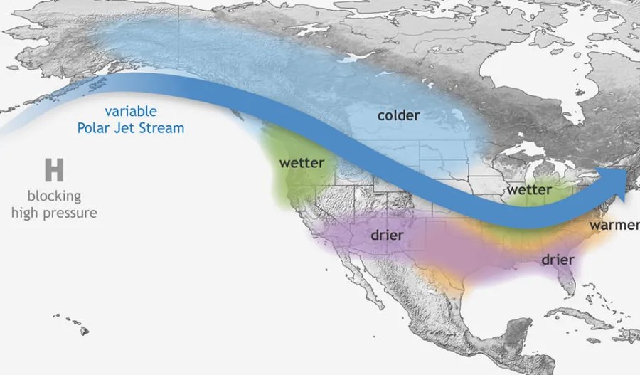
La Niña affects the position of the polar jet stream, which affects the weather we see on land.
The jet stream bisects the country, bringing wet weather to the Pacific Northwest and the Ohio Valley.
Southern states, on the other hand, typically experience dry and warm weather. This could worsen drought conditions, especially in the Southwest and California, regions that rely heavily on winter rains.

“Here in the Washington, D.C., area, we generally have year-round rain,” Mike Halpert, deputy director of the Climate Prediction Center, told Nexstar in 2022 as the country braced for a triple-dip La Niña.
“So if you have a few dry months, that’s okay because you can make up for it another time. If you’re in California or the Southwest, 90 percent of your rain falls in the fairly short winter and spring seasons. So if you miss that, you’re not going to make it up in the summer.”
What happens during a weak La Niña winter?
A weak La Niña is expected this year, which could make the weather more unpredictable.
The Climate Prediction Center said Thursday that “a weak La Niña is unlikely to result in traditional winter effects, but it is still possible that predictable signals could influence forecast guidance.”
Basically, a “classic” La Niña event is unlikely to occur, but it is possible. For example, we had a weak La Niña event last winter as well, but the effects were pretty textbook.
“In particular, much of the southern United States and northern Mexico were predicted to be drier than average, and that turned out to be the case, with parts of southern Arizona and New Mexico experiencing record dryness,” explained meteorologist Nat Johnson. “Wetter conditions were predicted, and rain did occur in the northern part of the continent, particularly parts of Alaska and the Pacific Northwest, and further south in Central America.”
While the forecast wasn’t perfect, with much wetter weather in eastern Texas, Arkansas, Kentucky and western Virginia, the overall La Niña pattern continued, Johnson said.
If this year’s La Niña event turns out to be completely typical, winter precipitation across the country will look like the map below. California and the South experience a dry season, while the blue belt of northern and midwestern states experiences a wet or snowy season.

What happens next?
La Niña is expected to last through most of the winter, but could subside by early spring. The Climate Prediction Center said there is a 55% chance of seeing a transition to “ENSO neutral” between January and March 2026. “ENSO neutral” means that neither La Niña nor El Niño is occurring.
It is too early to tell what will happen later this year, but at this point it seems more likely that we will see an El Niño event than a repeat of La Niña.

